January 1, 2016 map with roadway corridor
House Bill 959 was signed into law on July 11,2016 as Session Law 2016-90. One action of this law was the rescission of all transportation corridor official maps adopted pursuant to the Transportation Corridor Official Map Act.
In response to the passing of this law, the roadway corridor map layer has been removed from the current Forsyth County Tax Administration maps. If you would like to see the location of the roadway corridor when it was in effect, you can view the map by accessing the Assessment Map Archives. "September 23, 2016 Tax News Story regarding the Passing of House Bill 959."
Search Old Map Book
This is a search of the images of all the old large map books. These map books were constructed in 1952 and were updated until 1988.
Enter a block and click the Show Map Book button to continue.
Search Owner Ledger
Beginning in 1988, parcel ownership was maintained in the Owner Ledger until January 1, 2004. This search accesses the images of those books.
Enter a block and click the Show Owner Ledger button to continue.
Maps by Year
* 2010 Maps UnavailableHow to use the Assessment Maps
To use the Assessment Map Archives, click on the year you are interested in researching such as 2012.
There you will find a list of all tax maps as of 1/1/2012.
Let's say your PIN is 6835-36-3505.000.
Use the first four digits of the Parcel Identification Number (PIN) to select the appropriate map P 6835. Please notice you have the option of P 6835.01, P 6835.02, P 6835.03 or P 6835.04. This is due to the map being cut into quadrants. You will use the middle two numbers of the PIN to locate the quadrant you need. Using the Quadrant Grid map you will see that block 36 is in quadrant 01. So, you will select P 6835.01 from the list.
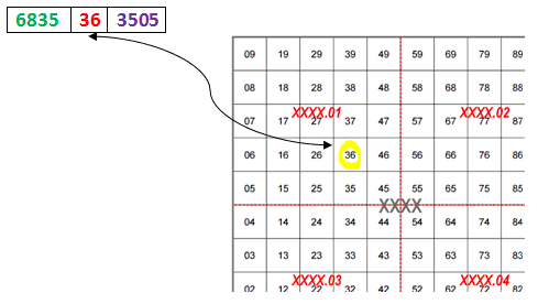
Once the map is displayed you use the last four digits of the PIN (3505) to locate the parcel on the map within block 36.
Note: It is important to note that the dimensions of lot lines included on all information maintained by the Forsyth County Tax Administration are calculated for tax purposes only. The acreage of a tax parcel may not match the deeded or platted acreage of the parcel. Similarly, the dimensions included on tax maps may not match the legal lot dimensions included on a plat or deed. To access information on the legal lot dimensions of a parcel, you can locate the deed of the parcel by accessing the Deeds tab on Detailed Property Information or going to the Register of Deeds Look Up
Additionally, all information displayed on the Assessment Map Archives is correct as of January 1 for the corresponding year.
If you have any questions about these maps or how to use them, please call the Tax Customer Care Center at 336-703-2300.
Online Tools


County Services